KKarakoram in the North and the Great Himalayas in the South. Ladakh is a mountainous desert located at altitudes ranging from 9000 ft. to 25000 ft. situated at the western edge of the Tibetan Plateau. The Ladakh landscape has been modified and sculpted into spectacular shape by wind and water erosion over the millennia. The people of Ladakh exhibit a natural join de vivre and warm disposition. Their customs and lifestyle have continued from the past and the culture traditions are vibrantly alive and colorful.
About Ladakh history, the earliest inhabitants of Ladakh were the Khampa nomads, who domesticated yaks. The first settlement along the Indus River was established by Mons from the region of Kullu and another tribe called the Brokpas, toward the west of Ladakh, originating from Giglit. Gya became the first seat of government of a Mon ruler who was known by the name of Gyapacho. Around 10th century AD in ladakh history, nomads from Khotan launched a series of bloody invasions in Ladakh. Gyapacho succeeded in repelling the attack of the Khotan nomads with the help of Skilde Nimagon, the decendant Kin Tibet. Gyapocho ceded to him the uninhabited Shey and Thiksey village in return of his help. Nimagon became the first king of Ladakh in ladakh history and chose Shey as the headquarter, and built a fort at Shey. Later he became the king of entire Ladakh region. Skilde Namagon ruled from 975 to 1000 AD. Between 1000 and 1500 AD Ladakh was ruled by succession of kings, who were great patrons of art and architecture. They were responsible for building palaces and promoting religious activities amongst other things. By the beginning of the 19th century in Ladakh history, the Mughal Empire had misshapen, and Sikh rule had been established in Punjab and Kashmir. However the Dogra region of Jammu remained under its Rajput rulers, the greatest of whom was Maharaja Gulab Singh whose General Zorawar Singh entered Ladakh in 1834. King Tshespal Namgyal was deposed and exiled to Stok. Ladakh came under Dogra rule and was integrated into the state of Jammu and Kashmir in 1846. It still upheld substantial independence and connections with Tibet. Throughout the Sino-Sikh war from 1841 to 1842 in history of Ladakh, the Qing Empire attacked on Ladakh and the Sino-Tibetan army was crushed.
The Dogras led by Zorawar Singh invaded Ladakh in 1834. King Dorjay Namgyal of Ladakh managed to hold the Dogra army at Mulbek for a few months. Eventually, they had to surrender. Ladakh was placed under the control of Gulab Singh and his Governer. This followed a constant strife by the Ladakhis to regain their freedom in Ladakh history. This bloody period ended with the advent of the British as the paramount power in North India. Ladakh was incorporated in the newly created state of Jammu and Kashmir.
General Information
| Area : | 98000 square Km |
|---|---|
| Population : | 135000 |
| Altitude : | Altitude Range from 9000 feet (2,750 M) at Kargil to 25,170 feet (7,672 M)atSaser Kangri in the Karakoram. |
| Best Season : | May to Early October |
| Language : | Ladakhi including Balti / Purgi, Shina or Dardic, Urdu / Hindi |
| Rain-fall : | 15cm, 6” (annual average) |
| Network : | Only Post Paid Connection of BSNL, Airtel, Vodafone are present there; othersplease check your operator’s collaboration. |
| ATM’s : | SBI, AXIS, PNB, J&K, HDFC, ICICI, IDBI etc. is available there (Still advisable tocarry hard Cash) |
Do & Don’ts
1. On Arrival by Air please rest for 24 Hours; to ensure that you have adequate time for acclimatization and sightseeing. As you travelling to High Altitude from Low, due to Low Oxygen.
2. Preferably spend at least Two days in Leh before you move out for visit to various destinations like; Pangong Lake Lake or Tso-moriri Lake & mountain passess like Khardungla La, Chang La etc.
3. Have plenty of Drinking Water. Preferably drink boiled, sterilized or packaged drinking water or any kind of liquid (except Alcohol)
4. While visiting any Gompa please take a Lamas Permission for Photo or Video Shoot
5. Please wear proper clothing while visiting Gompa; for female – NO Open Hair, Short Skirts or any short Dresses not allowed in Gompa. And for Male – NO Short Pant or Sleeveless not allowed in Gompa.
6. Carry moisturizer, Lip Balms, Sun Screen Lotions and Skin Nourishing Creams in your travel kit. Use Sunglasses when you outdoors & carry adequate quantity of drinking water along before moving out for sightseeing’s.
7. Avoid over eating (it sorts out most of gastric troubles). Do not consume Alcohol and avoid smoking.
Internal Transport:
Main public transport is provided by mini bus services. Tourist transport is essentially by Taxi/Cabs which are easily available at fixed rates. A National Highway that includes the Zoji La Pass connecting Srinagar to Leh cuts through Kargil. This highway is open for traffic only from May to November every year due to heavy snowfall at the Zoji La Pass.
Accommodation:
Leh has a variety of accommodation options is hotels and guesthouses. Most of the Hotels are family run establishments. In remote areas such as Nubra Valley accommodation is available mainly in guesthouses and in residential houses converted into paying guest OR in variety of Tents/Camps accommodation. In the past few years some good hotels and guest houses come up.
Climate:
The climatic conditions are mainly desert type and dry with little OR no rainfall. Summer temperatures rarely exceed 27 degree Celsius while in the Winters it may plunge to –20 degree Celsius. During winters most part of Ladakh are snow bound and all the land approaches are blocked.
Acclimatization:
If you are travelling to Leh by Air, you must allow a full day of complete rest for getting used to the high altitude and low Oxygen level. High altitude sickness is a risky condition faced by visitors who do not allow sufficient time for proper acclimatization.
Clothing:
During summer cotton with light woolens, a wind parka for occasional use and sturdy hiking shoes. In winter time, heavy woolens including down-filled wind proof Jackets/Parka and Thermal Inners also sturdy hiking shoes.
Inner Line Permits:
For visiting Khardung La Pass, Nubra Valley, Pangong and Tsomo-riri Lakes and the Dah-Hanu area of Leh District. It is mandatory for foreign tourist to obtain Protected Area Permits from The Deputy Commission office at Leh.
Festivals:
Ladakh is famous for the festivals held in the major Buddhist Monasteries annually. The main features of these festivals are the dance-dramas enacted by Lamas donning colorful robes and fearsome masks representing various Buddhist deities. They perform mimes symbolizing key aspects of the religion and its history. The Hemis festivalld in July – August is the most famous event. Every 12th year a huge Thangka of Padmasambhava, founder of Tibetan Bhuddhism is ritually exhibited during this festivals.
How to Reach:
By Road, The main overland approach to Ladakh is the 434 km Srinagar – Leh highway, which is open from May to November. This historic road passes through Kashmir’s picturesque countryside till Sonmarg (86 km) before ascending the Zoji La pass (3529 metre), it also crosses Fatula Pass (4095 metre) and Namik La (3737 metre).
The other land approach is the 473 km Manali – Leh Road is open from July to September. This runs across 5 passes, the lowest being Rohtang La (3878 metre) and the highest is Taglang La (5360 metre). J&K State Road Transport Corporation operates regular bus services between Srinagar and Leh, while Himachal Pradesh Tourism operates coaches on the Manali to Leh Route. Tourist transport is essentially by variety Taxi/Cabs which are easily available at fixed rates on this both routes.
By Air, Major Airlines operate regular flights to Leh from Delhi and shuttle services to Srinagar and Jammu once and twice a week respectively. Leh Airport is 6 km from the City Centre.
Most of Tourist Attraction Places
Leh
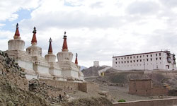
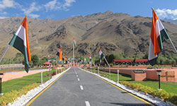
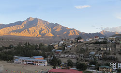
Leh the erstwhile capital of the kingdom of Ladakh is now a dream destination of many and the Mecca of adventure enthusiasts! Leh, one of the coldest deserts in the world is located at a distance of 434 Kms from Srinagar and 474 Kms from Manali (Himachal Pradesh). At the time of reorganization of districts in 1979, Ladakh was divided into Leh and Kargil and now Leh district is synonymous with Ladakh and vice-versa! Built by the Buddhist kings of Ladakh in 1553 the Leh Palace was once the world’s highest building. The primary attraction within the Leh city this palace is structurally similar to the Potala Palace in Lhasa. Now only the palace prayer room lives up to the sense of former grandeur of Leh Palace. Leh is a backpacker's haven with numerous trekking trails, valleys, and picturesque lakes. Renowned as the land of monks and monasteries there is lots to see in this amazing piece of land. There are three sub divisions of Leh with 7 different tour circuits identified for international tourists in Leh with breathtaking Himalayan panorama.
Leh local Sightseeing
LEH PALACE:
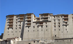 Leh Palace was built during the 17th century by the ruler King Sengge Namgyal. Its construction is on the same lines as the construction of the Potala Palace in Lhasa, Tibet. This palace had to be deserted by the royal family in the middle of the 19th century, because of the taking over of Ladakh by Dogra forces. After this the royal family is living in-exile in the popular Stok Palace. The Archaeological Survey of India (ASI) is restoring some of the ruined portions of this nine-storey palace. While the store rooms were on the lower floors, the royalty resided on the upper floors. The roof of this palace offers an excellent view of the valley.
STOK PALACE:
 Stok Palace, built by King Tsespal Tondup Namgyal in 1825, in the present times is the presidential palace of the royal descendants of King Sengge Namgyal. The architecture of this palace is a perfect mix of the traditional and the contemporary architectural styles. This palatial property consists of a number of beautiful gardens as well as a library that has around 108 volumes of the Kangyur (a collection of teachings of Lord Buddha). The palace is located around 15 kms away from the main city of Leh. This palace hosts an annual dance-mask festival in which there is a huge participation by the locals. There is also a collection of royal clothing, crowns and other important things which you can see while on the excursion of the palace.
HALL OF FAME:
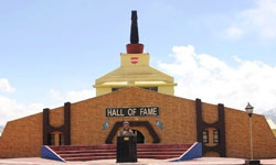 The Hall of Fame, located near the Leh Airfiled, is a museum constructed as well as maintained by the Indian Army in the memory of the soldiers who had lost their lives during the Indo-Pak wars. It is also termed as a memorial for the war heros. This building consists of two floors. While on the ground floor, there is information about the brave soldiers as and a souvenir shop but on the first floor, there are artifacts of various wars (mainly Kargil war) such as the weapons used during the war and some important documents, related to the same. There is another section dedicated to the Siachen Glacier.
SHANTI STUPA:
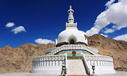 The Shanti Stupa is white-colored domed-shaped structure, located in Chandspa which looks extremely beautiful during night when it is illuminated. This peace pillar was built a ‘peace sect’ of Japanese Buddhist organization to celebrate the completion of 2500 years of Buddhism and for the promotion of world peace. It was inaugurated by His Holiness, the Dalai Lama in 1985. This pillar is known for its gilt panels depicting the life stories of Lord Buddha. It is just 5 kms away from the main city of Leh and is surrounded the traditionally built houses of the locals and snow-covered mountains. Take the steep slights to reach the Stupa that offers beautiful sunrise and sunset views.
JAMA MASJID:
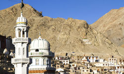 Located in the heart of Leh town is the Jama Masjid, which is one of the major historical mosques in Ladakh. This mosque is considered to be the biggest mosques in the Ladkah region and consists of a memorial which is known as Shahi Hamdan. This memorial is made in dedication to Mir Syed Ali Hamdani, a Muslim Sufi Saint. It was built in 1666-67 A.D. as a result of an agreement between Aurangzeb, the Mughal Emperor and the then ruler of Ladakh, Deldan Namgyal. Since the time of its construction, the mosque has been dismantled and re-constructed using new techniques.
Nubra
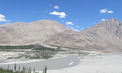 Nubra Valley lies about 150 km north of Leh where the Rivers, Shyok and Siachan, meet form a large valley. This valley separates the Ladakh from the Karakoram Ranges and the famous Siachen Glacier lies to the north of the valley. To the northwest of Nubra valley, lies The Sasser Pass and the famous Karakoram Pass of the 'Silk Route' fame which connect Nubra with Xinjiang. Panamik village is the last settlement in the northern end of in Nubra valley is open to tourists. Nubra valley has a lot to offer and is as a must do for everyone who travels to Leh It has been identified as a tourist circuit by the local administration of Leh district.
Diskit is the headquarters of the Nubra Valley and thus has lot of government offices with basic facilities. There is a line of shops in the market selling mostly local items to the tourists as well as to the locals. Tourist attractions in Nubra valley include Diskit monastery (3200 metres), located on a rocky spur just above the flood plains of the Shyok river, commanding views up and down the Nubra valley. It is the oldest and largest Buddhist monastery (Gompa) in the Nubra Valley of Ladakh region belonging to the Gelugpa (Yellow Hat) sect of Tibetan Buddhism.
Just near the Diskit monastery there is a very large statue of Maitreya Buddha facing the Shyok River down below in the valley. Believed to be World’s tallest Maitreya Buddha, the impressive 32 metre (106 feet) statue is located on top of a hill. The construction work of the statue was started in April 2006.
Panamik is situated about 150 kilometers from the Leh town across Khardung La pass in the Nubra valley. Located close to Siachen glacier, the highest battlefield in the world, this village is famous for its curative hot water springs that contain high concentrations of sulphur believed to be best for curing rheumatism and other ailments. Samstanling Monastery or gompa is a well-known Buddhist site in the Nubra Valley. Situated between Kyagar and Sumur village, it was founded by Lama Tsultrim Nima.Ensa Monastery. The monastery located atop a hill overlooks the snowcapped mountains of the Nubra Valley.
Khardung La Pass
 Khardung La (Khardung Pass, la means pass in Tibetan) is a mountain pass located in the Ladakh region of the Indianstate of Jammu and Kashmir. The local pronunciation is "Khardong La" or "Khardzong La," but, as with most names in Ladakh, the romanised spelling varies.
The pass on the Ladakh Range lies north of Leh and is the gateway to the Shyok and Nubra valleys. The Siachen Glacier lies part way up the latter valley. Built in 1976, it was opened to public motor vehicles in 1988 and has since seen manyautomobile, motorbike and mountain biking expeditions. Maintained by the Border Roads Organisation, the pass is strategically important to India as it is used to carry supplies to the Siachen Glacier.
The elevation of Khardung La is 5,359 m (17,582 ft) Local summit signs and dozens of stores selling shirts in Leh incorrectly claim that its elevation is in the vicinity of 5,602 m (18,379 ft) metres and that it is the world's highest motorable pass.
Khardong La is historically important as it lies on the major caravan route from Leh to Kashgar in Central Asia. About 10,000 horses and camels used to take the route annually, and a small population of Bactrian camels can still be seen at Hunder, in the area north of the pass. During World War II there was an attempt to transfer war material to China through this route.
Camel Safari in Hunder Sand Dunes
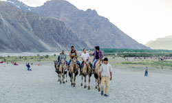 About 12,000 ft above sea level, 150 km north of Leh, lies the Nubra Valley, one of the highest deserts in the world where many are lured to experience the Camel Safari. On the double humped Bactrian camel in Hunder and Diskit, travel over the Ladakhi sand dunes. Our camel safaris start from Hunder, where you will make an acquaintance with the Mongol inhabitants, and will go on to explore never before experienced locales along the non-motorable side of Shyok River, all the way to Turtuk at the border!
Camel Safaris through Ladakh are one of the most memorable experiences possible in the Himalaya with a difference. You’ll soon get used to the rolling and wobbly movements of the camel while exploring fertile and lush apricot orchards, rugged mountain terrains, frozen desserts, and the remote villages of Nubra Valley.
In addition to the villages and scenery, we’ll stop at colorful Buddhist Monasteries and have a dip in the famous hot springs of the region which are said to possess therapeutic qualities.
TURTUK – The Last Village in India Pakistan Border
 Turtuk is the last Indian outpost before Pakistan in Ladakh and the Northernmost villages in India. Lying on the banks of Shyok River, it is a very secluded, military-dominated, and sensitive area, as merely ten kilometers ahead is the border or line of control between India and Pakistan. Known as erstwhile Baltistan, the place was under Pakistani control till 1971, so it is predominantly Muslim, and the people here speak Urdu, Ladakhi, Balti, and Hindi. It is the gateway to the Siachen Glacier, with the snow-clad peaks of Mt. K2, visible in the horizon from the top of the village.
Turtuk has only been opened to tourists since 2010 and is therefore a hidden gem. To write about it is almost like exposing a secret, for to go there is like a journey of discovery that one has been privileged to gain access to, a mystical world that one might otherwise never know existed; yet the place leaves an indelible impact that needs to be shared.
It is quite a trek to get to Turtuk, as it is far from the town of Leh. You might be able to hop onto a shared taxi or rent a car, by far the best option, but it is completely worth the arduous journey. It takes about eight to nine hours to get to Turtuk, and it is advisable to stop at Hunder, Nubra Valley overnight if one wants to see both places. Foreign nationals have to obtain permits to enter Turtuk, and these can be obtained through a travel agent beforehand in Leh. Indians can enter showing a government-approved id.
The landscape, culture, language, clothing, and even the physical features of people change quite drastically crossing over into Turtuk, technically entering Baltistan.
On entering this quaint little place through a rickety wooden bridge with heavy military security, a sense of tension and gravity envelops the atmosphere; photography around the bridge is strictly prohibited due to the sensitive nature of the location. Grey, ash-like sand, heat, and dust build up like a cloud on the riverbanks, with miles of nothingness except your jeep and maybe a few locals working on the roads here and there. Time seems to stand still along with the stillness of the hot air, due to the road maintenance, which tends happens quite often on journeys such as these.
Turtuk is made up of a couple of villages, one of the main ones being Pharol, which sits atop a hill. There are several little camps and guesthouses that have cropped up in this small hamlet, which can be discovered while walking around its many narrow paths, but hard to find on the web. It might be a good idea to book through a travel agent or ask the locals for directions after reaching Leh. Turtuk Holiday camp has nice tented accommodations, although they are perhaps a tad more expensive than the smaller guesthouses in the main village. Aesthetically done up with modern bathrooms and a little sit out in front, they cost no more than Rs. 2000 per person per night in peak season. The food is fairly simple but tasty. Everything is vegetarian since it is difficult to maintain poultry due to the remote location. The camp is located on the base before you enter the main village and hence is a bit remote. The popular place to stay in Turtuk, and perhaps the nicest, however, is the recently opened Maha Guest House. It has all modern features and amenities including a little garden café, which serves snacks and tea to outsiders as well, not to mention that it lies hidden amidst the fields and narrow lanes of the village of Pharol, adding to its charm.
There isn’t really much to do in Turtuk, except trek to the village and the monastery at the top. On the way across the hanging bridge, there is a beautiful brook adjacent to the war memorial for those who fought the Indo – Pak war in Kargil.
Pharol itself is a very calm place with agricultural fields of barley and apricot trees growing everywhere. A few houses and guesthouses dot the meandering lanes. Shy, yet friendly girls and children hop around the village, curious to know and meet the rare breed of tourists they come across. Their garb is very different from the rest of the locals in Ladakh, with bright, colorful, contrasting floral prints that stand out amidst all the greenery and stone houses.
At the edge of the hill, there is a cliff from which the entire horizon is visible, with spectacular views of the riverbanks, the underlying plains, and the peaks of Pakistan. Walking down to the plains across the military outpost, just a few kilometers before the Pakistan border, it is remarkable to sit and watch the sunset atop one of the many boulders as dusk sets in, absorbing the quiet yet somber beauty of Turtuk.
To travel to a place is not just to get there; it’s all about the journey, especially on a road trip through Ladakh. It’s the feeling a place evokes, being there in the moment; if it is unable to stir emotions that form a lasting impression, it was quite meaningless to have gone there. To look at the landscape from a distance with squinted eyes, this village could just as well mimic the Italian countryside, with tall Viridian green trees contrasted against pale ochre patches of barley. There is a desire to linger on, the sense of being a part of a time warp into the past that would change if exited. Could such a place exist in the realms of reality? Or was this an accidental door opened to Alice’s secret wonderland, such that being a privy to it as outsiders was much like seeing through the looking glass?
Kargil
 Almost equidistant, at a little over 200 kms from Leh and Srinagar, the Kargil is second largest town of Ladakh situated on the banks of Suru river. It is nestled in the Himalayas, giving it a cool, temperate climate. Summers are warm with cool nights, while winters are long and cold with temperatures often dropping to -40 °C with recorded temperatures of -60 °C in Drass situated 56 km from the Kargil town. Situated at an altitude of 2704 metres, Kargil serves as an important base for undertaking adventure tourism. It also offers thrilling opportunities of rafting, camping and mountaineering. Kargil is inhabited by people, said to have been originated from Dards and Tibetan nomads who got settled along the river valleys. While walking through Kargil main market, one can observe the architectural wonders. The houses are made of stone and mud to escape the rigours of biting cold in winters.
Because of its vital importance, the town is growing at a steady pace and new shops, hotels and restaurants are coming up fast. The tourists on way to Leh break their journey in this beautiful mountainous town for a night halt. However, Kargil has much to offer tourists that any other place in Ladakh barring Leh.
Rangdum is the most isolated part of the Suru Valley situated 130 kms South-east of Kargil and serves as an important trekking base. An adventurous trek from here leads to Kishtwar and then to Kashmir valley.
Kargil has some of the loftiest mountain peaks in Jammu and Kashmir. The Nun (7,135 m) and Kun (7,035 m), pair of Himalayan peaks are the highest mountain peaks in the state. They can be approached from Tangole (70km from Kargil) and Gulmatongo (110km from Kargil).
Kargil was also located on the ancient Silk Route and has been a trading centre for centuries together. Its cultural variety is due to the people of different areas who settled here time to time.
Zanskar
 Zanskar Valley is about 20 kms. South of Rangdum. The most isolated of all the trans Himalayan Valleys. The Panzila Top (4401 m) is the picturesque tableland adorned with two small alpine lakes and surrounded by snow covered peaks. As the Zanskar road winds down the steep slopes of the watershed to the head of the Stod Valley, one of Zanskar's main tributary valleys, the majestic "Drang-Drung" glacier looms into full view. A long and winding river of ice and snow, the Drang-Drung" is perhaps the largest glacier in Ladakh, outside the Siachen formation.
Zanskar comprises a tri-armed valley system lying between the Great Himalayan Range and the Zanskar mountain; The three arms radiate star-like towards the west, north and south from a wide central expanse where the region's two principal drainage's meet to form the main Zanskar River. The area remains inaccessible for nearly 8 months a year due to heavy snowfall resulting in closure of all the access passes, including the Penzi-la. It is mainly along the course of this valley system that the region's 10,000 strong, mainly Buddhists population lives. Spread over an estimated geographical area of 5000 sq. kms. High rise, mountains and deep gorges surround Zanskar. To-day, Zanskar has the distinction of being the least interfered with microcosms of Ladakh, and one of the last few surviving cultural satellites of Tibet. Within the mountain ramparts of this lost Shangrila stand a number of ancient yet active monastic establishments. Some of these religious foundations have evolved around remote meditation caves believed to have been used by a succession of famous Buddhist saints for prolonged meditation in pursuit of knowledge and enlightenment.
The 240 km long Kargil-Padum road, of which the first 90 km stretch is paved, remains opened from around mid-July to early November. In June, the summer is at its height in the region and the climate is ideal for trekking along the route free from vehicular traffic of any kind and when the countryside is freshly rejuvenated into life after months of frigid dormancy.
Drass
 Drass (3230 m), 60 km west of Kargil on the road to Srinagar, is a small township lying in the centre of the valley of the same name. It has become famous as the second coldest inhabited place in the world by virtue of the intense cold that descends upon the valley along with repeated snowfalls during winters. Winter temperature is sometimes known to plummet to less than minus 40 degrees. The Drass valley starts from the base of the Zojila pass, the Himalayan gateway to Ladakh. For centuries its inhabitants are known to have negotiated this formidable pass even during the most risky period in the late autumn or early spring, when the whole sector remains snow-bound and is subject to frequent snow storms, to transport trader's merchandise across and to help stranded travellers to traverse it. By virtue of their mastery over the pass they had established a monopoly over the carrying trade during the heydays of the Pan-Asian trade.
A hardly people enduring with fortitude and harshness of the valley's winter, the inhabitants of Drass can well be described as the guardians of Ladakh's gateway. Drass is a convenient base for a 3-day long trek to Suru valley across the sub-range separating the two valleys. This trek passes through some of the most beautiful upland villages and flower sprinkled meadows on both sides of the 4500 mts high Umbala pass, which falls enroute. The trek to the holy cave of Amarnath in neighbouring Kashmir, which stars from Minamarg below Zojila, takes 3 days and involves crossing of 5200 mts high pass. Drass also offers numerous shorter treks and hikes to the upland villages.
Lakes Of Ladakh
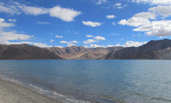
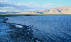
Pangong Tso:-The Pangong Lake is 160 kilometer from Leh and offers spectacular views of the region. The lake is surrounded by mountains and the color of the lake changes shades throughout the day. This famous blue brackish lake is located on the India China border and is approximately 5 kms wide and over 144 kms long. Majority of the lake body falls in the Chinese territory. Spangmik, the farthest point to which visitors are permitted, is only some seven kilometer along the southern shore from the head of the lake and you can view the Changchenmo range, their reflections shimmering in the ever-changing blues and greens of the lake’s brackish waters.
Tso Moriri Lake:
 The Tsomoriri Lake is a beautiful mountain bounded expanse of water, around 240 Kms. from Leh in Rupsho Valley. The Lake is located at 14,000 ft. near a small village of Korzok. The Korzok Monastery of 19th century, houses Shakyamuni Buddha and other statues. Nomadic people grazing their herd of goats and yaks makes for an outstanding feature of this area,
Tso Kar Lake:
 Tso Kar – The smallest of the three high altitude alpine lakes in Ladakh region is situated in Rapshu in the southern part of Ladakh.Not far from the famous Tso moriri Lake is Tso Kar Lake.The Tso-Kar Lake also known as ‘White Lake’The nomadic people Changpas are most outstanding feature of this area. They can be seen moving from one place to other grazing herds of goats, sheep and yaks. Changpas pass their days with their animals and move with their flocks, their only wealth from pasture to pasture according to changing season. Their flocks, their yaks, and goat’s hair furnish the raw material of which they make their ropes, their clothes and shoes. All day long men and women are busy milking, churning the milk into butter, making ropes, weaving mats and other fabrics. These people have been completely beyond the pale of all civilizing influences. Even towards the fag end of the twenty first century, they belong to a primitive pre-historic age, The Drive is scenic andTsokar lake is one of the best.
Tso kar Lake is easy to access and lies at a distance of 160 km from Leh. It lies 30 km west from Leh-Manali Road and 540 km from Srinagar.